 |
|
|
|
Note: To download a copy of the original Word
document,
right-click on one of the links below and choose "Save As..."
(Word Document, 410KB) or ZIP file (77KB)
October 27, 1999
Mr. Stewart King
Acting Chair, North Plains Planning Commission
P.O. Box 537
North Plains, OR 97133
Dear Mr. King and Planning Commission members:
Friends of North Plains applauds your decision on October 13th to delay adoption of findings in support of a UGB expansion. We realize and respect the amount of time you have put into the Periodic Review process over the past several years. We understand how frustrating it must be to have new information such as a revised findings document, land swap proposals, and feedback from DLCD dropped on you at the last minute.
As a commission, you are caught in the unenviable position of balancing the desire of the public to see North Plains grow with minimum impact on existing neighborhoods with the non-negotiable requirements of state-wide planning goals and state statutes. We would like to offer our response to some of the points raised by DLCD’s letter of October 13. We hope that it will help you adopt findings that will meet the needs of North Plains’ residents, as well as survive what we believe will be inevitable legal challenges to any decision you make.
In addition to the deficiencies noted by Meg Fernekees in her letter, we believe that the proposed findings reach conclusions that are unsupportable based on current law. They are based on the Periodic Review documents, which contain several legal and numerical errors that we feel leave the City quite vulnerable to legal challenge. In brief, these errors are:
When all of these items are correctly evaluated, we conclude that North Plains’ current UGB will easily accommodate its growth to the year 2020. We believe that a legally-defensible land need figure is 0 (zero) acres, rather than the 204 acres that the findings indicate. Therefore, any discussion of UGB expansion at this time would be premature.
We believe that we have legal justification for each of the above positions. Our detailed analysis, including the recalculated land need, is presented in the remainder of this document. We urge the City to consider these points carefully, as we believe they are both objective and legally correct.
1. Population projections
Our primary concern is with the population projection. As the DLCD memo states, the City of North Plains must coordinate its population projections with Washington County. 1 It is insufficient to claim that the TGM study represents such coordination for three reasons:
Furthermore, several events have occurred since the Study was completed that have a significant impact on how North Plains must coordinate its population with the county. Most importantly, on December 16th, 1997, Governor Kitzhaber signed Executive order 97-22, which requires state agencies to use State Office of Economic Analysis (OEA) population projections when coordinating with counties on population projections. Therefore, OEA figures must be the base facts for all local population projections.
Second, while the TGM study used OEA projections as part of its supporting data for population projections, those numbers have since been revised downward by the OEA.
DLCD has indicated 3 that during coordination between a city and a county, they will consider the OEA projections in a fashion similar to the "safe harbor" provisions of Planning Goal 5, and that a city’s historical share of county-wide growth will be the starting point for determining the city’s share of future growth. For North Plains, that percentage has ranged between .003 and .004 since 1970 (the first US Census conducted after incorporation of the city). These figures are shown in the table below.
POPULATION COMPARISONS
1970 |
1980 |
1990 |
1998 |
|
| North Plains | 690 |
715 |
992 |
1760 |
| Washington County | 157,920 |
245,808 |
311,554 |
397,600 |
| NP % of County | .004 |
.003 |
.003 |
.004 |
Using the latest OEA data, Washington County’s population is expected to grow from 397,600 in 1998 to 598,800 in the year 2020. Based on the table above, North Plains’ share of the expected 201,200 new residents of Washington County would be between 604 and 805. These increases would yield a year 2020 population for the City ranging from 2364 to 2565.
DLCD vs. Douglas County, LUBA 96-233, established that variation from these projections would need to "have an adequate factual base [that] is identical to the substantial evidence requirement for quasi-judicial decisions." 4 We do not believe that the Study’s projections would satisfy this requirement in the event of a legal challenge. Therefore, it would be in the City’s best interest to adopt a population projection consistent with OEA projections.
Given that a recent survey of North Plains’ citizens showed that 50% of those responding favored a town size of 2500 in 2020 5 , it would be in keeping with its citizens’ desires to adopt a population figure of 2500. Only 27% selected the next higher choice (3000 persons), further indicating that residents strongly favor lower population projections than have been adopted. Our land needs analysis (presented below) thus uses a population projection of 2500 persons.
2. Density targets
Recently, the Commission discovered that existing zoning does not allow the City to meet its current density target of 8.4 units/acre. Despite Staff opinion that the City could meet the target without too much difficulty, and repeated recommendations to stay with the 8.4 figure, the Commission disregarded this input and adopted a lower density target. The City cannot arbitrarily adopt a lower density figure just because rezoning would be required to meet an existing, higher density target. Doing so would place the City at risk for legal challenge.
Indeed, it is easy to meet the target. For example, rezoning a mere 5.1 acres to mixed use (with a 14 units/acre planned density per Metro guidelines 8 ) would do it:
acres |
housing units |
avg. density |
|
| Existing infill capacity and density 9 | 34.8 |
264 |
7.6 |
| Added mixed-use lands | n |
14*n |
14.0 |
| Capacity at desired density | 34.8+n |
264+(14*n) |
8.4 |
If "n" is the number of mixed-use acres needed, then the desired density (8.4) is the new total units divided by the new number of acres:
8.4 units/acre = 264+(14*n) units ÷ 34.8+n acres ð n = 5.1 acres
Some Commissioners have attempted to justify a lower density by saying that the public opinion survey indicates that the public will not support higher density. While this may be true, it must be pointed out that 8.4 units/acre is the existing density target, so adopting this figure is consistent with public preference.
Our land needs analysis thus uses a target density of 8.4 units/acre and a household size of 2.84 persons.
3. Redevelopment analysis
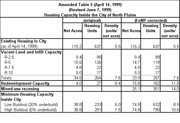
Land Use Planning Goal 14 also requires "[e]ncouragement of development within urban areas before conversion of urbanizable areas." 12 Although we have repeatedly mentioned the need to consider redevelopment and rezoning, the City has failed to address this issue when computing its housing capacity. Rezoning, specifically rezoning to allow mixed commercial and residential use, is one of the most powerful tools for achieving efficient land use. In fact, the TGM Study identified about 25.1 acres of land as "mixed use commercial corridor," 13 but the City has failed to include it in its housing capacity calculations. The areas identified are consistent with DLCD’s requirement that "[redevelopment] strategies shall address developed lands designated Commercial and Industrial located near the Commercial and Main Street intersection and along Glencoe Road." 14
Item 5 in the above-referenced letter states that the City must "[a]nalyze [the] Study’s Preferred Alterative[sic] by additional planning work that formulates a[n] Urban Growth Management Plan consistent with local input, Goals 1, 2, 5, 7, 10, 11, 12 and 14 and Metro’s Functional Plan requirements." The Metro requirements include guidelines for the planning the density of mixed-use development. These guidelines describe several development types; the types relevant to Commercial/Main and Glencoe are "Town Center" and "Main Street." The density for planning purposes of these types is 40 and 39 persons/acre respectively. Using North Plains’ household size of 2.84 persons yields a density of 14 units/acre for this type of mixed-use development.
In our analysis of potential mixed-use areas, we have assumed that only lands currently zoned C-1 and C-2 would be converted to mixed commercial/residential use. We excluded any TGM-designated parcels currently zoned for residential use (.9 acres of R-5 land), as well as specific parcels that obviously have little or no realistic chance of being re-developed (i.e., city hall, the fire station, the bank, Chevron, McDonald’s, the medical center, and so on). The remaining parcels comprise 25.1 net acres identified by the TGM study as available for mixed-use development. We have added the residential capacity to the housing capacity inventory, based on a density of 14 units/acre. 15 As is the nature of mixed-use development, the land area is also counted as available for commercial use.
The City’s inventory also failed to include all of the "redevelopment opportunity areas" identified by the Study. In addition to the 4 acres at the southwest corner of North Road and Glencoe mentioned in the text, the map shows an 11.8-acre area west of Main street. We have included this area in our revised inventory.
Our revised Housing Capacity analysis (commonly known as "Table 5") is shown below, with the City’s figures presented for comparison:
4. Land needs analysis
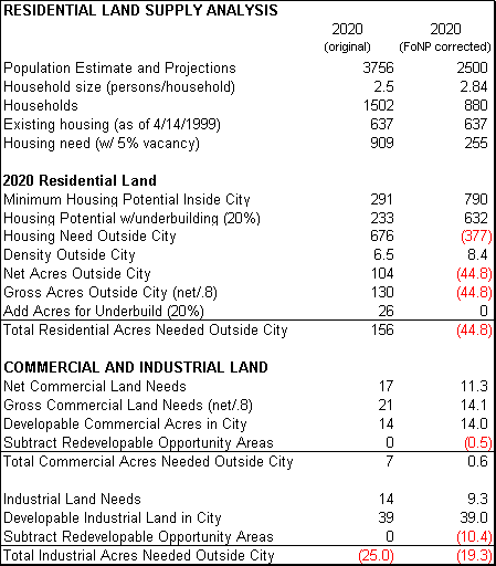
The tables below show the results of applying all of the above considerations. In our analysis, we have attempted to exactly duplicate the City’s analysis, then supply our updated data alongside the original data for easy comparison.
The first table is patterned after the "Summary of Land Needs and Redevelopment Analysis (06-14-99)" presented in the June 21, 1999 packet. We excluded the "2040 Residential Land" section because it is not relevant, and the "Parks, Schools, Other Institutional Uses" section because it did not change. Our updated Commercial and Industrial land needs reflect the lower population projection, and were obtained by scaling the original numbers by the ratio of the two population figures. For example, our updated Commercial land need is 17*(2500÷3756) = 11.3 acres. The table reflects the updated housing potential shown in the revised Table 5 above.
The total land needs are summarized in the table presented below, commonly referred to as "Table 6". Our source for this table is Page 2 of the "Land Needs Analysis Amendments to the Convergence Document (06-14-99)" in the June 21, 1999 packet.
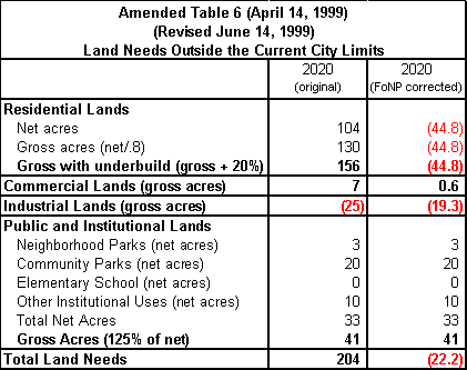
Note that the City’s original land needs analysis projects a 25-acre surplus of industrial lands in 2020. However, instead of deducting this excess from land needs, the City Planner arbitrarily reserves it "as a contingency," 16 thereby creating additional need that a UGB expansion would remedy. This is the very same situation, among others, that led to the LUBA remand of Metro’s rural reserves decision. 17 In order to comply with State Land Use laws, the City is required to provide "Maximum efficiency of land uses within and on the fringe of the existing urban area" (Goal 14) and "preserve and maintain agricultural lands" (Goal 3). Arbitrarily disregarding excess industrial lands, which could be rezoned to provide needed residential lands, is not in compliance with these requirements. In our revised land needs calculations, we have reduced the needs by the amount of the excess industrial lands.
5. Conclusion
We have shown that a rigorous analysis of the City’s population, housing capacity, and rezoning and redevelopment opportunities yields a markedly different result than the findings proposed for adoption. We submit that our analysis would be far more likely to survive a legal challenge.
In closing, we hope that this analysis will be of help to you in responding to DLCD. We would like to see the City proceed toward an orderly completion of its Periodic Review process and emerge with a product that not only meets statutory requirements and will stand up to all legal challenges, but addresses the needs and desires of the citizens of North Plains. As can be seen, these are not contradictory goals, but instead readily complement each other.
If you have any questions, please contact James Just at 647-5023 or Brian Beinlich at 647-2163.
Thank you,
| James Just | Brian Beinlich |
| Friends of North Plains | CPO-8 |
cc: Don Otterman, City Manager
John Rankin, City Planner
Meg Fernekees, DLCD Field Representative
Mary Kyle McCurdy, 1000 Friends of Oregon
References:
1. October 13, 1999 memo from Meg Fernekees to the North Plains Planning Commission, p.3.Last modified 2000-12-27.
Friends
of North Plains
phone: (503) 647-5023 e-mail: info@fonp.org
Web site problems?
Contact the Webmaster.